Barenkopf Peak Hike
Barenkopf Peak Hike Route
Route: Barenkopf Peak Hike
Difficulty: Moderate
Distance: 5.6 miles / 9 kilometers
Elevation change: 2089 feet / 637 meters
Estimated time: 4 hours
Rating: 9 / 10
Type of trail: Loop
Step by Step Directions
Getting to the start
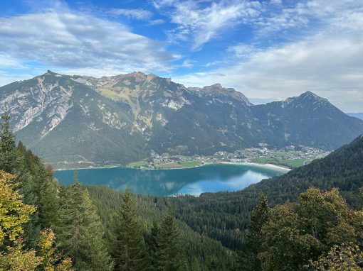
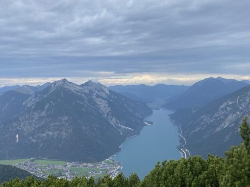
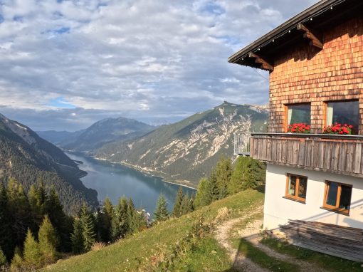
Barenkopf is part of the Karwndel Mountains and is the summit with the best view of Lake Achensee, and only spot you can see the entire lake. To reach the start of this hike, you will need to take the Karwendel-Bergbahn cableway to the top which is found in Pertisau, Achensee. The Karwendel-Bergbahn cableway operates every 15 minutes in both directions and takes riders to the top of Zwolferkopf, with opening hours changing by season. Note a round trip ticket on the cable car costs 20 euros / person with the Achensee card discount. The Achensee card is provided by accommodation hosts in the area.
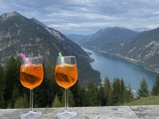
Once at the top of the cable way, the hike begins. Keep in mind, the first 20 minutes will be repeated at the end as well. Before beginning, if you require a restroom, the Alpengasthaus Karwendel to the right of the gondola has restrooms available.
Beginning the trek
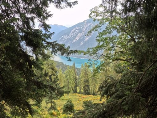
Begin the hike by taking a left off the gondola and walking down the wide gravel road. Follow signs pointing towards Barenkopf (2 hours) and Barenbadalm (30 minutes). Don't worry, you will only be on a gravel road for about 20 minutes. Once at the bottom of the slight downhill, you will see another direction sign (yellow arrows). Follow the path towards Barenbadalm (15 minutes), taking a right to continue on the wide gravel road. You will pass a viewpoint which you can climb up to see a nice view of Lake Achensee. Then continue onwards until you reach Barenbadalm. Barenbadalm is a hut and has a restaurant, keep this in mind as you will pass by here again towards the end of the hike.
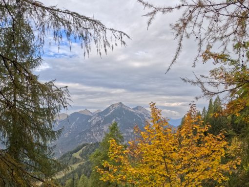
At this point, you start the loop. Veer left before reaching the Barenbadalm hut and start traversing up the grassy path towards Barenkopf (1 hour 30 minutes). The path will take you into a forest and trees around you. This portion of the hike is largely uphill, some parts quite steep, but this encompasses almost all the elevation of the hike. The trail takes you in and out of the trees, with mountains peaking through to show off their faces and peaks along the way. The views are continuous and changing on this portion of the hike.
Out and back to Barenkopf
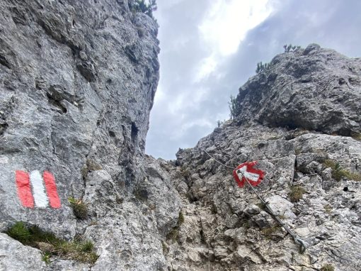
Once you reach a decision point, continue straight towards Barenkopf (20 minutes) rather than turning right. This next portion of the hike is an out and back, but takes you to the fabulous viewpoint over Lake Achensee. Shortly after passing the sign, you will reach a spot where you have a short, nearly vertical climb. Don't worry, there is a cable on the side of the rock to help you climb the small section. Once a top this, the next bit of uphill is also supported with a cable on the rock side of the path. The cable is quite helpful as the path is made of a lot of small rocks which move easily, so the cable helps in holding your balance. After the cable section, there is a short steep section without a cable which can be a bit challenging without good shoes or hiking poles. However, there are taller plants on the cliffside of the walk, making the path feel safe and less daunting. This section is harder going down than going up as you need to focus on your balance.
The path will shortly open up into a wide meadow and you'll be able to see mountains much further in the distance in different directions than the views you've had so far in the hike. Continue onward to the end of the path (marked with a cross) to reach Barenkopf. Enjoy the panoramic views here. Backtrack to the meadow and consider enjoying a snack here before carrying on.
A steeper downhill
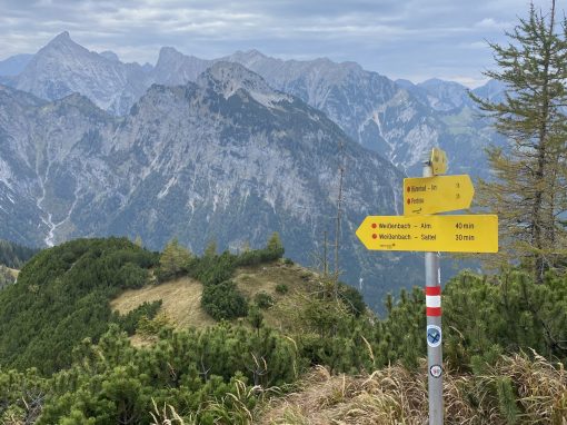
Once ready to go, head back the way you came, traversing down the path. As mentioned above, the section leading up to the cable is the most challenging as it is a bit steeper and the small rocks make it more challenging to get good fitting. For those with hiking boots / shoes or hiking poles, this will not be a problem. For those less prepared, it's always an option to slide down the short distance. Then grab onto the cable and use the cable until you reach the vertical section. Again, use the cable built into the rock to climb down and now you're done with the challenging section here. Trek back to the dividing point, this time taking a left towards Weissenbachsattel (30 minutes) and Weinbenbach Alm (40 minutes). The next 15 minutes will be a steep decline on a rock and mud path. Take it slow and make your way down. Once you reach the bottom of the steep section, the rest of the hike is very manageable without any technical or more challenging sections.
Finishing the Loop
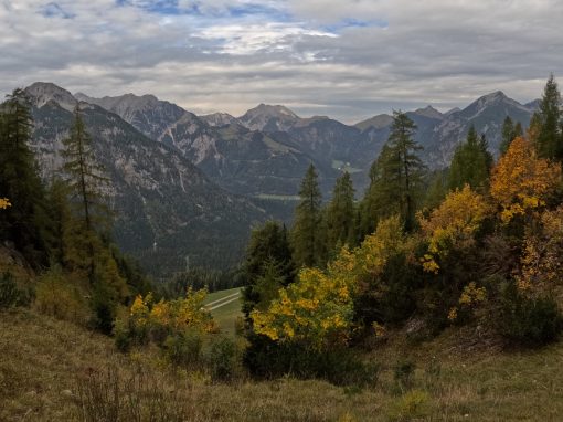
The hike will open up into a meadow and provide a pleasant walking path. This is a nice change of pace after the initial long climb followed by a quick descent. Once you reach Weissenbach Sattel, you will take a right at the sign turning towards Barenbadalm. This section will take about 40 - 50 minutes. Along this section you will be traversing through the woods again, with a few spots supported by cable on the walls, but these really are not challenging sections and the cables just provide an extra support. Enjoy the views of the mountains around you as you walk up to Barenbadalm. From here, you have finished the loop and will take the same path you took at the very beginning of the hike.
The end of the journey
Head past Barenbadalm and walk along the gravel path, taking a left uphill. The path winds a bit and again will pass the little viewpoint you can climb up to for a view of the lake. Continue onwards and take a left up the hill; here you are within 300 meters of your end point. The Karwendel-Bergbahn cableway marks the end of your hike. Hop back on the gondola and head down to the base, or consider grabbing a post hike snack and drink at the Alpengasthaus Karwendel just past the gondola.