Ziller Valley
This page may contain affiliate links; please note I only recommend places I feel are of value and all information shared is my own thoughts and opinions.
Transportation and Accommodations
Getting There
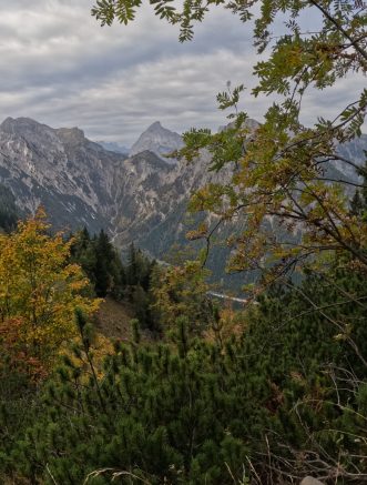
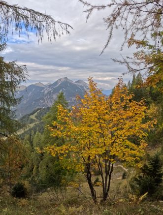
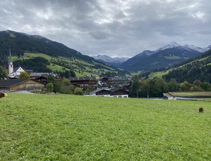
The Ziller Valley is an area found in the Tyrol region of Austria, drawing people to visit for skiing in the winter or hiking and other outdoor activities in the summer. With seven regions in Austria, Tyrol is found towards the western side of Austria, but not the furthest west. The region is sandwiched between the border of Germany and Italy, and is home to the town of Innsbruck and many beautiful mountains and lakes. A few areas to note include Lake Achensee, Alpbach, Lake Seebensee, Lake Drachensee and the Zillertal Alps which are a mountain range boarding Austria and Itay.
If traveling to the Ziller Valley from outside of Austria, the best airports to travel into will be Innsbruck and Salzburg. The distance depends a bit on where you pick to stay, but Innsbruck is closer than Salzburg. The area around Lake Achen is a nice home base in the area, which is located about a 1 hour drive from Innsbruck and a 2 hour drive from the town of Salzburg. You will need a car to reach this area as it is not easily accessible with public transportation. If planning just to stay in Achensee, it is possible to book a transfer to accommodations, but this will limit what you are able to do on the trip. Thus, it is recommended to rent a car from the airport and head to the area!
Getting Around
In order to explore the areas around Lake Achen, you will need a car. There are various rental car options from both airports, with all common rental companies available. Although there are buses and some taxis available in the towns, having a car opens up opportunities and provides flexibility in timing and exploring. It also enables you to plan on the above and avoid being tied to the bus schedule.
Accommodations
When visiting the Ziller Valley, there are a variety of towns you can stay in. We chose our accommodations based on an appealing offering in the tiny town of Maurach. The accommodations had a grocery store walkable and a few restaurants, the necessities but very limited. That being said, I would gladly stay at this specific accommodations again and highly recommend as it is a beautiful location.
Urban Alpine Penthouse with Lake View
Views are stunning, there's a rooftop hot tub, kitchen with all you could need, large windows, a sauna, fireplace and generally very cozy quarters.
Others towns around Achensee include: Pertisau, Maurach, Achenkirch, Wiesing, and Steinberg am Rofan.
Alternatively, you can stay further from Achensee and check out the larger town of Mayrhofen. This is a cute and larger town, often used as a base point for those doing an active holiday in the area. It is larger and therefore has more restaurant and basic options, but also is a good access point to reach nice hikes, or if visiting in the winter, ski slopes.
Things to do and see
Hiking
Olperhutte mountain via Freisenberghaus
Difficulty: Moderate
Distance: 9 miles / 14.5 km
Elevation change: 3050 feet / 930m
Estimated time: 5.5 - 7.5 hours (including breaks)
Rating: 10 / 10
Type of trail: Loop
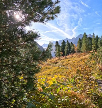
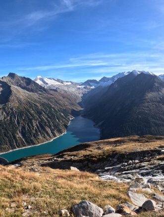
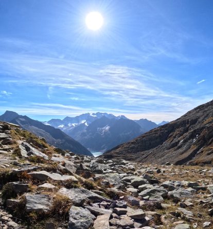
This hike starts at the Schlegeisspeicher reservoir. Best to get an early start and plan to begin at 10 am at the latest if you want to budget in time to enjoy the views and not rush. Reaching Schlegeisspeicher is easiest done by car, but there are also public bus options for those without a car. The reservoir is reached by traveling along the Schlegeis Alpine Road toll road. The toll road costs 15.50 euros per car and can only be paid in CASH. The road is typically open from May until mid October, but can vary depending on the season (ie - a colder autumn with early snowfall can close the road earlier). Be sure to check online to determine if the pass is open. The pass is open from the May to June and September to October from 7 am until 6 pm, and from 6 am until 6 pm in July and August. A portion of the road immediately after the pay point is a one-way road, so there may be a queue when you arrive. The pass is open in one direction for a period of time (usually 10 minutes) and then switched to the other direction. As you drive along this road, you will be thankful they operate the road with this system as there are sharp, hairpin turns on narrow roads which would be next to impossible with two-way traffic and there is a tunnel which is only suited for one-way traffic. It will take about 10 minutes to drive from the pay point to the base of the reservoir. You will exit a tunnel and immediately on your left will be a small café; note there are public bathrooms available here (helpful for before starting a long hike!). Ahead there will be signs for three parking lots. For those following the below path recommendation, parking in P1 will put you closets to the starting point of the hike, while parking in P3 will be closests to the end point. The walk between P1 to P3 is only about 10 minutes and along a flat road so not too challenging at either section. There is no additional charge for parking so pick a spot and get on your way. Take a peak at the reservoir from this level before commencing the hike.
To find the starting point of the hike, head towards the direction of the tunnel you just drove through. Just past P1, but before the café and bathrooms area, there will be a path which starts on the left. If you look up to the left, you will see Dominikushutte. As you start on the path, follow the signs towards Friesenberhaus (2.5 hour) along trail 532. You will shortly see another sign pointing toward Friesenberhaus noting just 2 hours now. The trail will continue and you will pass over a small stream via a wooden plank. Continue upwards into the forest and on your way. You'll continue through trees for some time, with the mountains and reservoir poking through here and there. After some time, you will reach an area which opens up into a field. There are wooden planks along the path in a few areas here, helpful when the ground is wet as the area is a marsh. Soon you'll approach a little hut on your left, with running water available. Top off your water bottle and continue on your way. You'll have another hour or more from here until you reach Friesenberhaus. As you're above the tree line, most of this section is open and you'll have a large "rock field" that you wander through and around. You'll be able to spot Frisenberhaus long before you are there so keep an eye out and up for a view of the hut!
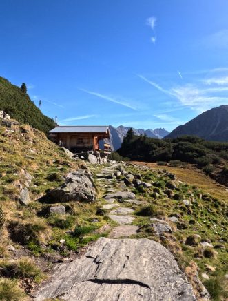
Once you reach Frisenberhaus, you're likely about 2-2.5 hours into your hike. The hut is open for hikers to book and stay overnight during the warmer summer months. With beautiful views, this is an excellent spot to take a break and enjoy a snack. You can even get lunch at the hut if you visit while it's open. The next portion of your hike will include a steep climb so fuel up here!
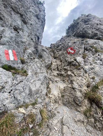
When you leave Frisenberhaus, follow the same path you took to reach the hut. Do not go behind the hut as these trails will lead to different destinations. You'll head down towards the Friesenbergsee Lake (body of water visible from the Frisenberhaus). Keep an eye out for a little wooden plank which sits over water. Cross the wooden plank and continue to follow the red and white trail markers on the rocks. This portion of the hike can sometimes be challenging to see in advance so the trail markers are especially helpful. You'll start an ascent immediately after crossing the water, eventually turning a corner and seeing a very steep climb to your left. Although daunting, it is not as bad as it looks, especially as you are only traversing up about 2/3 of the way (approx. 170 meters). This is the longest steep portion of the hike so power through and take breaks along the way to keep it an enjoyable hike.
The path will eventually level off and you'll begin to walk along a mountainside trail. There are a few spots the path is quite narrow and there are often rocks in the ground requiring you to pay attention to your footing, but nothing too challenging to cover. You'll follow this lovely balcony trail for about 1 hour 30 minutes until you run into Olperhutte. Unlike Freisenbergsee, you will not see Olperhutte early and instead you will ultimately see the hut right as you are within five minutes of reaching it. Be sure to enjoy this section of the hike. The panoramic views of the mountains all around along with the reservoir beginning to peak through provides breathtaking views along the entire journey.
Once the Olperhutte shows its face, you'll also see the instagram famous bridge. Depending on when you are visiting, this might be quite busy as people queue to take their photo on the bridge with the optical illusion making it appear as they are on a bridge spanning over the reservoir, much higher than the reality of the photo as the bridge instead sits above a small stream. Plan to take another break here, getting your photos and enjoying a snack here too. If visiting from early June to early October, Olperhutte will be open so you can even grab a snack or bite to eat here!
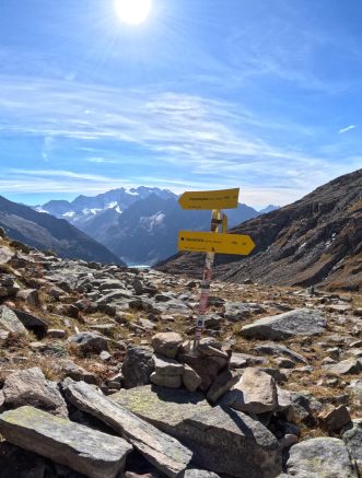
The last part of the hike is largely downhill. There are signs pointing to different trails next to Olperhutte. Follow signs towards the reservoir / Schlegeisspeicher (1 hour). The downhill will take 1 hour to 1 hour 30 minutes depending on your downhill pace. The downhill starts slowly but does get more dramatic as you ultimately are heading down to the base level of the reservoir. The path offers stunning views of the reservoir on the way down so it is still enjoyable with nice views. Once you reach the bottom, the path will end at parking lot 3. For those who parked in parking lot 1, cross the road and turn left to walk 10 minutes along the path next to the road. You'll pass a small waterfall on the left and continue onward until you reach your end point.
Barenkopf Peak
Difficulty: Moderate
Distance: 5.6 miles / 9 kilometers
Elevation: 2089 feet / 637 meters
Estimated Time: 4 hours
Rating: 9 / 10
Type of trail: Loop
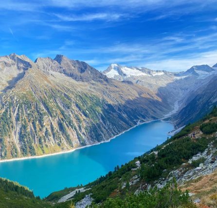
Barenkopf is part of the Karwndel Mountains and is the summit with the best view of Lake Achensee, and only spot you can see the entire lake.
To reach the start of this hike, you will need to take the Karwendel-Bergbahn cableway to the top which is found in Pertisau, Achensee. The Karwendel-Bergbahn cableway operates every 15 minutes in both directions and takes riders to the top of Zwolferkopf, with opening hours changing by season. Note a round trip ticket on the cable car costs 20 euros / person with the Achensee card discount. The Achensee card is provided by accommodation hosts in the area.
Once at the top of the cable way, the hike begins. Keep in mind, the first 20 minutes will be repeated at the end as well. Before beginning, if you require a restroom, the Alpengasthaus Karwendel to the right of the gondola has restrooms available.
Begin the hike by taking a left off the gondola and walking down the wide gravel road. Follow signs pointing towards Barenkopf (2 hours) and Barenbadalm (30 minutes). Don't worry, you will only be on a gravel road for about 20 minutes. Once at the bottom of the slight downhill, you will see another direction sign (yellow arrows). Follow the path towards Barenbadalm (15 minutes), taking a right to continue on the wide gravel road. You will pass a viewpoint which you can climb up to see a nice view of Lake Achensee. Then continue onwards until you reach Barenbadalm. Barenbadalm is a hut and has a restaurant, keep this in mind as you will pass by here again towards the end of the hike.
At this point, you start the loop. Veer left before reaching the Barenbadalm hut and start traversing up the grassy path towards Barenkopf (1 hour 30 minutes). The path will take you into a forest and trees around you. This portion of the hike is largely uphill, some parts quite steep, but this encompasses almost all the elevation of the hike. The trail takes you in and out of the trees, with mountains peaking through to show off their faces and peaks along the way. The views are continuous and changing on this portion of the hike.
Once you reach a decision point, continue straight towards Barenkopf (20 minutes) rather than turning right. This next portion of the hike is an out and back, but takes you to the fabulous viewpoint over Lake Achensee. Shortly after passing the sign, you will reach a spot where you have a short, nearly vertical climb. Don't worry, there is a cable on the side of the rock to help you climb the small section. Once a top this, the next bit of uphill is also supported with a cable on the rock side of the path. The cable is quite helpful as the path is made of a lot of small rocks which move easily, so the cable helps in holding your balance. After the cable section, there is a short steep section without a cable which can be a bit challenging without good shoes or hiking poles. However, there are taller plants on the cliffside of the walk, making the path feel safe and less daunting. This section is harder going down than going up as you need to focus on your balance.
The path will shortly open up into a wide meadow and you'll be able to see mountains much further in the distance in different directions than the views you've had so far in the hike. Continue onward to the end of the path (marked with a cross) to reach Barenkopf. Enjoy the panoramic views here. Backtrack to the meadow and consider enjoying a snack here before carrying on.
Once ready to go, head back the way you came, traversing down the path. As mentioned above, the section leading up to the cable is the most challenging as it is a bit steeper and the small rocks make it more challenging to get good fitting. For those with hiking boots / shoes or hiking poles, this will not be a problem. For those less prepared, it's always an option to slide down the short distance. Then grab onto the cable and use the cable until you reach the vertical section. Again, use the cable built into the rock to climb down and now you're done with the challenging section here. Trek back to the dividing point, this time taking a left towards Weissenbachsattel (30 minutes) and Weinbenbach Alm (40 minutes). The next 15 minutes will be a steep decline on a rock and mud path. Take it slow and make your way down. Once you reach the bottom of the steep section, the rest of the hike is very manageable without any technical or more challenging sections.
The hike will open up into a meadow and provide a pleasant walking path. This is a nice change of pace after the initial long climb followed by a quick descent. Once you reach Weissenbach Sattel, you will take a right at the sign turning towards Barenbadalm. This section will take about 40 - 50 minutes. Along this section you will be traversing through the woods again, with a few spots supported by cable on the walls, but these really are not challenging sections and the cables just provide an extra support. Enjoy the views of the mountains around you as you walk up to Barenbadalm. From here, you have finished the loop and will take the same path you took at the very beginning of the hike.
Head past Barenbadalm and walk along the gravel path, taking a left uphill. The path winds a bit and again will pass the little viewpoint you can climb up to for a view of the lake. Continue onwards and take a left up the hill; here you are within 300 meters of your end point. The Karwendel-Bergbahn cableway marks the end of your hike. Hop back on the gondola and head down to the base, or consider grabbing a post hike snack and drink at the Alpengasthaus Karwendel just past the gondola.
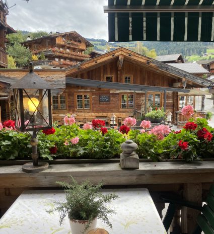
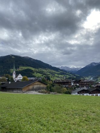
Alpbach
Quintessential Austrian town with beautiful views of the mountains with Austrian style houses, hotels, and shops spread throughout the town. Alpbach is well worth a stop or a slight detour to take in the picturesque and cute town. Park your car, walk around the town, grab a meal or a coffee and carry on your way. It can also be a good home base for skiing or hiking holidays.
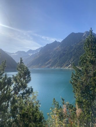
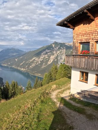
Achen Lake
As the largest lake in Tyrol, many travel here to enjoy the water and its surrounding area. Rent bikes or take a nice long walk (approx. 13 km) around the lake. Hop in for a swim or jump on a boat to get out on the lake.
The area around Lake Achensee has some incredibly hikes, as there are mountains surrounding the lake on all sides. Head out on one to enjoy views from a bird's eye view above!
Food and Drinks
Gasthaus Jodlerwirt Maurach
Maurach
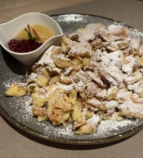
Small Austrian restaurant in town serving many traditional dishes. The décor and furniture is similar to many other old fashioned Austrian restaurants. The service is alright, and the inside of the restaurant unfortunately will have some flies but this seems to be a norm in the warmer months. That being said, the food is tasty for an Austrian meal and convenient for those staying in Maurach. Do not miss the Kaiserschmarrn
Alpengasthaus Karwendel
Pertisau
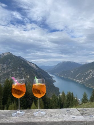
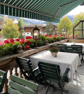
This restaurant is found at the top of the Karwendel-Bergbahn cableway, just a few minutes walk to the right once you’ve reached the top. They have both indoor and outdoor seating, and there's a great view over the lake from here. Grab a table, order a drink (coffee, aperol spritz, beer, cola or whatever you fancy!) and some Austrian snacks. This is especially nice after completing a hike before catching the gondola back down to the base.
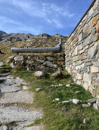
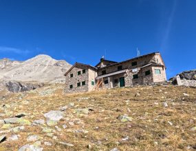
Friesenberhaus
Hut open with food and drinks accessible only by foot for hikers to grab a snack or drink, and for those spending the night to enjoy a meal
Olperhutte
Hut open with food and drinks available to enjoy inside or on the terrace with beautiful views over the Schlegeisspeicher reservoir. Only accessible on foot so hikers can enjoy after hiking up to the hut located at 2,389 meters
Hotel Zur Post
Alpbach
A cute little hotel sitting in the town of Alpbach is very inviting to visitors. We stopped in here and sat down for breakfast and a coffee. The waiters were so friendly, even opening the kitchen to be able to serve us after breakfast hours were completed. Try the Kaiserschmarrn here if you have a sweet tooth and are stopping in for a sweet breakfast or afternoon treat.
Austrian Foods to try
- Wiener Schnitzel - thinly sliced breaded pork or veal and often served with a lemon to provide an additional kick along with sides of fries, potato salad or a side salad
- Kasespatzle - similar to a macaroni and cheese or cheesy pasty dish, it is usually served with small noodles and coated in melted cheese
- Goulash with potato dumplings - similar to a beef stew with slow cooked beef and typically served with a round potato dumpling which often soaks up the extra sauce quite nicely
- Tiroler Grostl - this Austrian dish is a mix of sliced, roasted potatoes served with bacon or other beef meat and a fried egg on top
- Meat plates - often Austrian restaurants serve a meat plate with a variety of meats and sausages, typically served with a side of fries or similar
- Kaiserchmarrn - ultimately a dense apple pancake broken up into lots of different small pieces. Often served with apple sauce, or occasionally other fruits such as plums and topped with powdered sugar. This sweet treat is a must try for breakfast, an afternoon treat, or dessert to wrap up a tasty meal
- Apple Strudel - another Austrian dessert, the apple strudel is more like a piece of apple pie. It is baked apples served in pastry often with a custard or thicker vanilla sauce
Other Notes
Duration
This very much depends how much time you'd like to spend in the area. A long weekend is enough to get a taste of the area and check out a few hikes or ski in the winter. If you are up for a longer adventure, you could spend a week here and use it as a homebase to travel to different areas (noting you may want to plan to cook in some evenings or drive to dinner in other towns as options in the small towns will be limited) or use this as a stop along a longer road trip.
Time of year
The best time of year to visit depends on what activities you're keen to enjoy.
For hiking, June to September is ideal noting July and August are high season so although longer sunlight days and a better chance of good weather, prices are likely to be higher and areas will be busier. This can make shoulder season appealing, which typically includes late May through June and September through early October. Shoulder season does carry a bigger risk with weather. If the winter season has had a lot of snow and the spring stayed cold, paths may stay closed due to snow still being on them in the earlier months. Alternatively, late September and October can run the risk of having a colder autumn and early snowfall. Nevertheless, shoulder season can also bring gorgeous weather with quieter trails.
For those looking to ski, ski season tends to run from late December through early March. As the Austrian alps are not known for being as tall as others, they depend on more snowfall so January and February tend to be the best time to plan a ski trip.
April through early May and mid October through mid December often are very quiet in the region, with many hotels / pensions and restaurants closing their doors for the short time period. This is the true off season so even the restaurants and accommodations will take a break in line with the quiet time period.
Navigation
Transportation and Accommodations
Things to do and see
Food and Drinks